Business forum discussions
Search Engine Optimisation for laymen and newbies
24 comments
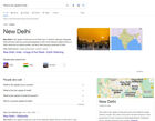
Finally, is 2023 the year Google search became irrelevant?
7 comments
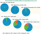
2005 - 2022 the rise and fall of mobile traffic - and why
4 comments

Contacting your Tax Office | HMRC Help lines

Contacting my Royal Mail Local Delivery Office
6 comments
Levitate Aerial Imaging
Levitate Aerial Imaging
Esher
Surrey
United Kingdom
Tel: 020 3478 0609
Website:
https://www.levitate-aerial.co.uk/
https://www.levitate-aerial.co.uk/
Business type:
Surveying & construction
Drones benefit surveying & construction industries, from land and building surveys, to mapping, progress reports and even site security.
Property
We deliver numerous benefits from stunning marketing materials and property showreels, to cost-effective security and building inspections.
Surveys & inspections
Our drones are perfectly suited to detailed aerial surveys, roof inspections, construction site progress, time lapse filming and crop monitoring.
Filming & photography
Visual media is integral marketing and advertising, but providing a new perspective can be challenging (and expensive).
Mapping & modelling
Levitate Aerial Imaging uses the latest software to generate 3D models and high definition orthomosaic maps.
Leisure & tourism
Our high resolution imagery enhances websites, advertising and promotional materials.
Insurance
We support more accurate quotes and post-incident assessments, reducing operational costs and mitigating risk.
Opening Times
Mon
08:30AM - 06:00PMTue
08:30AM - 06:00PMWed
08:30AM - 06:00PMThu
08:30AM - 06:00PMFri
08:30AM - 06:00PMPayment Methods Accepted
MAESTRO, PAYPAL, VISAELECTRON, MASTERCARD, CHECK, VISA, APPLEPAY
MAESTRO, PAYPAL, VISAELECTRON, MASTERCARD, CHECK, VISA, APPLEPAY
Services:
Aerial Filming, Aerial photography, Aerial Modelling, Aerial Assessments, Aerial Mapping, Drone Piloting
Editing or updating this listing
Update your details here if you are unaware of any log-in information for this listing.Disclaimer
Opinions expressed within reviews are those of the individual author and are not the views or opinions of Lowi Ltd, My Local Services or any of its employees.If you have an issue with any review comments then please fill in the review issue form and include as much detail as possible.
If you want to report incorrect information on this web page, then please contact us and outline the issue. We aim to resolve most problems within one business day.